Katimavik-Hazeldean
A planned Kanata neighbourhood between Highway 417 and Hazeldean Road, with treed streets, connecting pathways and many small parks.
Katimavik-Hazeldean is in south-central Kanata, in Ottawa's west end. Population: 11,440 (2021).
Updated · Facts on this page link to their sources
About Katimavik-Hazeldean
Katimavik-Hazeldean is in south-central Kanata, in Ottawa's west end. Wikipedia bounds it by Eagleson Road to the east, Hazeldean Road to the south, the Carp River to the west and Highway 417 to the north. It was developed from the early 1970s, starting with the Chimo Drive area, and was named "Katimavik" ("Gathering Place") in 1972 after a local contest. The 2021 census counted 11,440 people in 4,390 private dwellings, with 81.3% owner households (Ottawa Neighbourhood Study).
Boundaries
Wikipedia bounds Katimavik-Hazeldean by Eagleson Road to the east, Hazeldean Road to the south, the Carp River to the west and Highway 417 to the north. The map outline is the Ottawa Neighbourhood Study boundary 'Katimavik - Hazeldean', which may differ slightly at the edges. Wikipedia places it in Kanata South Ward.
Homes
The 2021 census shows 49.1% single-detached houses, 39.1% row houses, 3.2% semi-detached, 7.2% apartments in buildings under five storeys and 1.3% in buildings of five or more storeys. Condominium dwellings are 28.8% of homes, and 81.3% of households own. Wikipedia says the Chimo Drive area kept its original look: wide, heavily treed lots, set-back houses and no sidewalks. Newer parts between Kakulu and Hazeldean roads are somewhat denser. ons-sqo.ca
- Many small parks joined by footpaths, including Young's Pond Park, Cattail Creek Park and Hazeldean Woods Park
- Kanata Leisure Centre and Wave Pool and Kanata Recreation Centre nearby
- Katimavik Elementary, Castlefrank Elementary, Holy Redeemer and Roger-Saint-Denis are the elementary schools named by Wikipedia; Holy Trinity Catholic High School is the high school
- Groceries and bakeries along Hazeldean Road, and Food Basics on Katimavik Road
- About 20.3 km in a straight line to Parliament Hill; 23.1 km and 21 minutes by road in free-flow, no traffic
- In the 2021 census, 49.1% of dwellings were single-detached and 39.1% were row houses
- Katimavik-Hazeldean Community Association (khca.on.ca)
Community
How Katimavik-Hazeldean came to be
- 1866
By 1866 Hazeldean was a small post village of about 50 people in Goulbourn Township, with one general store, one common school and one church shared by several congregations. en.wikipedia.org
- 1970s
Campeau Corporation began developing the Chimo Drive area between Katimavik and Kakulu roads in the early to mid 1970s, in the garden-city style used in Beaverbrook across the highway. Other developers followed in the 1980s and early 1990s. en.wikipedia.org
- 1972
The community was named "Katimavik", meaning "Gathering Place", in 1972, after a local contest won by 12-year-old Kanata resident Corinne Friesen. en.wikipedia.org
- 1990s
The area between Katimavik Road and the highway was meant to be part of the Kanata Town Centre. Much of it was later rezoned for medium-density residential, and townhouses and detached homes were built there in the 1990s. en.wikipedia.org
- 2001
The former City of Kanata, which includes Katimavik-Hazeldean, amalgamated into Ottawa. en.wikipedia.org
Local names worth knowing
- Corinne Friesen
As a 12-year-old Kanata resident, she named the community "Katimavik" in 1972, in a local contest. en.wikipedia.org
- Chris Neil
The hockey player is listed by Wikipedia as a former resident. en.wikipedia.org
Around Katimavik-Hazeldean
Walking rings at 5, 10 and 15 minutes from the neighbourhood centre.
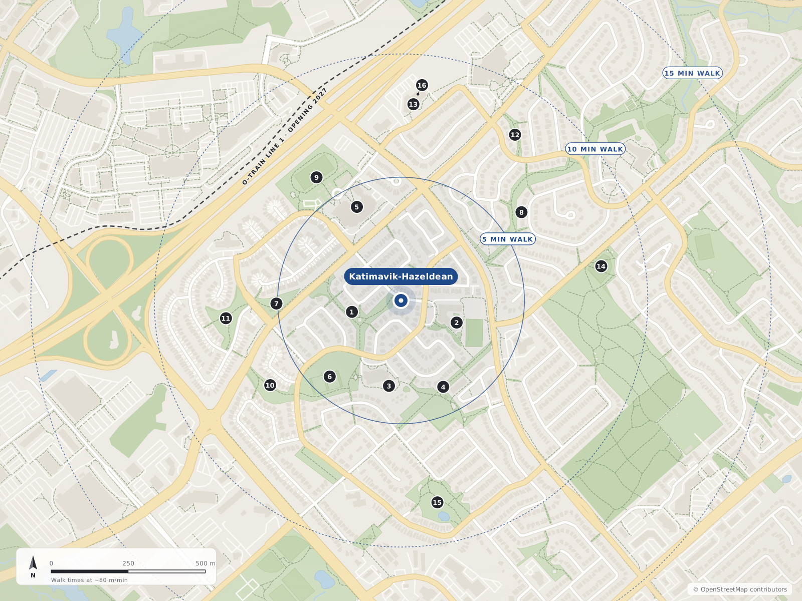
- 1Sewell Park160 m
- 2Castlefrank ES190 m
- 3Holy Redeemer School280 m
- 4Stonegate Park310 m
- 5Holy Trinity Catholic HS340 m
- 6Hayward Park340 m
- 7Davis Park400 m
- 8Escarpment Park (Chimo)490 m
- 9McGibbon Park490 m
- 10Dorey Park510 m
- 11Rowe Park570 m
- 12Byrd Park650 m
- 13Kanata Leisure Centre and Wave Pool660 m
- 14Shearer Park660 m
- 15Young's Pond Park670 m
- 16Kanata Wave Pool680 m
Schools
7 nearbyCastlefrank Elementary School
OCDSB55 McCurdy Driveopenstreetmap.org ocdsb.ca
190 m2 min walkHoly Redeemer School
OCSB75 McCurdy Driveopenstreetmap.org red.ocsb.ca
280 m4 min walkHoly Trinity Catholic High School
OCSB180 Katimavik Roadopenstreetmap.org trh.ocsb.ca
340 m4 min walkKatimavik Elementary School
OCDSB64 Chimo Driveopenstreetmap.org ocdsb.ca
890 m11 min walkPeak Centre Academy
1565 Maple Grove Roadopenstreetmap.org peakcentreacademy.ca
1.2 km15 min walkÉcole élémentaire catholique Roger-Saint-Denis
CECCE186 Barrow Crescentopenstreetmap.org
1.5 km19 min walkGlen Cairn Public School
OCDSB182 Morrena Roadopenstreetmap.org ocdsb.ca
1.6 km20 min walk
Straight-line distances from the Katimavik-Hazeldean centre. Living near a school does not guarantee a place: confirm the designated school for an address with each board. All schools and board locators.
Parks & places
10 nearbySewell Park
15 Sewell Wayopenstreetmap.org
160 m2 min walkStonegate Park
45 McIntosh Wayopenstreetmap.org
310 m4 min walkHayward Park
79 McCurdy Driveopenstreetmap.org
340 m4 min walkDavis Park
304 Davis Avenueopenstreetmap.org
400 m5 min walkEscarpment Park (Chimo)
111 Chimo Driveopenstreetmap.org
490 m6 min walkMcGibbon Park
62 McGibbon Driveopenstreetmap.org
490 m6 min walkDorey Park
80 McCurdy Driveopenstreetmap.org
510 m6 min walkRowe Park
41 Davis Avenueopenstreetmap.org
570 m7 min walkByrd Park
128 Chimo Driveopenstreetmap.org
650 m8 min walkKanata Leisure Centre and Wave Pool
Community or recreation centre
70 Aird Placeopenstreetmap.org
660 m8 min walk
Shops & dining
10 nearbyFood Basics
150 Katimavik Roadopenstreetmap.org
850 m11 min walkBulk Barn
457 Hazeldean Roadopenstreetmap.org
1.1 km14 min walkFarm Boy
457 Hazeldean Roadopenstreetmap.org
1.1 km14 min walkSimbad Bakery
471 Hazeldean Roadopenstreetmap.org
1.1 km14 min walkSultan Butchery
471 Hazeldean Roadopenstreetmap.org
1.1 km14 min walkNo.70 Cake
501 Hazeldean Roadopenstreetmap.org
1.2 km15 min walkWalmart
500 Earl Grey Driveopenstreetmap.org
1.2 km15 min walkThe Indian Supermarket
474 Hazeldean Roadopenstreetmap.org
1.3 km16 min walkAl-Balad Bakery
462 Hazeldean Roadopenstreetmap.org
1.3 km16 min walkStrawberry Blonde Bakery
767 Silver Seven Roadopenstreetmap.org
1.3 km16 min walk
Getting around
TransitDowntown (straight line)
About 20.3 km in a straight line from the neighbourhood centre to Parliament Hill.
Driving
23.1 km and about 21 minutes to Parliament Hill (free-flow, no traffic; rush hour takes longer).
Highway 417
Wikipedia lists three exits serving the area: Eagleson Road (138), Castlefrank Road/Kanata Avenue (139, a half-interchange) and Terry Fox Drive (140).
O-Train
Moodie station on the Confederation Line is the only O-Train station in our place list for this area. It lies outside the neighbourhood, so check the route before relying on it.
For sale in Katimavik-Hazeldean
No Katimavik-Hazeldean homes on katimavik.homes right now
Selling here? Get a website for your home, or browse every home for sale in the area.
Neighbouring areas
Quick answers
Short answers first; each links to the full answer and its sources.
Is Katimavik a good place to live?
Katimavik-Hazeldean is a neighbourhood in Kanata South, in Ottawa's west end. It had 11,440 residents in the 2021 census, and 81.3% of households owned their homes. 49.1% of dwellings were single-detached houses, and 82.6% of workers commuted by car.
As of 2021 · ons-sqo.ca en.wikipedia.org
What schools serve Katimavik?
Schools in or next to Katimavik-Hazeldean include Katimavik Elementary School (64 Chimo Drive) and Castlefrank Elementary School (55 McCurdy Drive), both Ottawa-Carleton District School Board (OCDSB). Ottawa Catholic School Board (OCSB) schools are Holy Redeemer School (75 McCurdy Drive) and Holy Trinity Catholic High School (180 Katimavik Road). École élémentaire catholique Roger-Saint-Denis (186 Barrow Crescent) is a French-language Catholic school run by the Conseil des écoles catholiques du Centre-Est (CECCE).
As of 2026-10 · openstreetmap.org openstreetmap.org
How far is Katimavik from downtown Ottawa?
From the centre of Katimavik, Parliament Hill is about 20.3 km in a straight line and 23.1 km by road. The drive is about 21 minutes in free-flowing traffic.
As of 2026-10 · router.project-osrm.org openstreetmap.org
What are homes like in Katimavik?
In the 2021 census, 49.1% of Katimavik-Hazeldean's 4,390 private dwellings were single-detached houses and 39.1% were row houses. 3.2% were semi-detached, 7.2% were apartments in buildings under five storeys, and 1.3% were apartments in buildings of five or more storeys.
As of 2021 · ons-sqo.ca en.wikipedia.org
What is the nearest O-Train station to Katimavik?
Moodie, on the Confederation Line (O-Train Line 1), is the only O-Train station in our data for the area, and it is open. It is about 6 km in a straight line from the centre of Katimavik, calculated from OpenStreetMap coordinates.
As of 2026-10 · openstreetmap.org en.wikipedia.org
Where do people in Katimavik buy groceries?
Food Basics is at 150 Katimavik Road. Along Hazeldean Road there is a Farm Boy and a Bulk Barn (457 Hazeldean Road), The Indian Supermarket (474 Hazeldean Road) and Green Fresh Supermarket Kanata (5487 Hazeldean Road). T&T Supermarket is at 300 Eagleson Road in Hazeldean Mall.
As of 2026-10 · openstreetmap.org openstreetmap.org